 dmd docs
Navigation & Routing
Point-to-point navigation with spoken, turn-by-turn guidance. Every route is calculated by the on-board DMD Router engine, so routing works offline — and you choose the routing profile, from fastest tarmac to hard offroad.
- Routing Engine
- DMD Router — on-board, works offline
- Start a Nav
- Search, long-press the map, a Favorite, a GPX route / waypoint, or a place shared from another app
- Routing Profiles
- Road Fast / Fun, Match Any Road, Offroad Easy / Medium / Hard, Advanced Adventure
- Guidance
- Turn-by-turn instructions + voice, with ETA & distance

Navigating — the route drawn on the map, the next turn top-right, and your position following the line.
Starting a Navigation
There are several ways to pick a destination — whichever you use, DMD2 calculates the route and starts guiding you:
Search
The Search button (Section 3) opens Location Search — type an address, place name or paste coordinates, or browse categories like Fuel, Restaurant and Accommodation. Type it the way you would say it: Rua da Boavista, Porto, Lidl Porto, Fuel, Porto or Rua da Boavista 601 — a town after the comma (or at the end) centres the search on that town, a number is taken as the house number, and a word like fuel, gasolina or farmácia runs that category there. Articles are optional (Rua Boavista finds Rua da Boavista). Results come from your offline maps and your own places first; the online index is only asked when there is no good answer among them (or on the HUB), and its results are then listed right after your places and the HUB’s. Every hit in the result list is also dropped on the map as a blue dot — tap a dot to open that place’s details, exactly like tapping its list entry.
Long-Press the Map
Long-press any point on the map to open its info bubble, then choose Navigate To to route there.
A Favorite Location
Tap a saved location on the Home Favorite Locations row to navigate straight to it.
A GPX Route or Waypoint
Open a loaded route or waypoint and choose Navigate To. Covered in the GPX guide.

Location Search — type a destination (street, town, place town, category, town, street + house number) or paste coordinates, browse POI categories, or pick from your saved and HUB locations (typing finds those too). While a result list is open, its entries show as blue dots on the map; tapping a dot opens the location’s details.
Your Places and the HUB in Search
Typed search also looks through your own places — everything in Location Manager, favourites included — by name, tag, address or short description. That works offline and needs no license. Signed in to the HUB with a license and online, it also finds matching HUB Locations and HUB Services; on a slow connection they join the list a moment after it appears. These results always head the list — your places first, then HUB Locations, then HUB Services, each with its best matches on top — and each wears the icon of its tile:
- Green outlined pin — one of your places, like the My Locations tile.
- Filled green pin — a HUB Location.
- Amber wrench — a HUB Service; the line under its name is the service type.
In portrait, tapping one of them zooms the map to it and its round info button opens its own page; in landscape, tapping it does both. Its dot on the map opens the page too. Your place opens the same page as tapping its pin on the map; a HUB Location or Service opens its Discover page — not the general location details, which would offer to save a place you already have. Leaving the HUB brings you back to Location Search.
Turn-by-Turn Instructions
While navigating, the instruction card sits in the top corner of the map. It always shows what to do next:

- GPX or NAV — a small blue badge on the card’s top corner names what you are following: NAV for a navigation you started, GPX for a GPX file you loaded. Both draw the same arrows and distances, so the badge is the quick way to tell which one the card is talking about.
- Next maneuver — a large arrow, the instruction (“Turn left”) and the distance to it. The card draws attention as the turn gets close.
- “then…” — a small preview of the maneuver after the next one, so quick pairs of turns don't surprise you.
- Distance & ETA — the flag line shows remaining distance to your destination and your estimated arrival time. Tap the time itself to flip every time on the card between arrival time and remaining travel time — a short Arrival / Remaining label flashes so you know which you’re looking at. The compact pill and the portrait progress bar follow the same choice.
- Track progress — a thin bar under the track or route name fills as you cover the current line, so you can see at a glance how far along it you are.
- Tap the card — tapping the instruction card itself opens Navigation Options, which is also where you stop navigating (route colour, profile, route info, Finish Navigation).
Rich On-Road Detail
Where the map data supports it, instructions are enriched with:
- Lane guidance — a lane strip shows which lane(s) to be in at complex junctions.
- Roundabouts — which exit to take is announced and drawn (“take the 2nd exit”).
- Road names — the road you turn onto is named in the instruction and voice prompt (e.g. “Turn left onto Main Street”).
- Motorway exits — exit numbers and signage are surfaced where available.
Voice Guidance
Spoken prompts announce each maneuver as you approach it — the same wording you see on the instruction card, so screen and voice stay in step. Balance the navigation voice against your music in Settings → Audio.
Language
Prompts are spoken in your device’s language — the same language the instruction card is written in. Nothing to configure: change the Android system language and the voice follows on the next start.
Distances follow the voice too, so a German device hears “1,5 Kilometer” and an English one “1.5 kilometers”.
Languages with translated prompts: English, German, Dutch, Polish, Czech, Hungarian and Norwegian. Any other system language uses English prompts and an English voice.
Navigation Options
Tap the instruction card to open the Navigation Options panel:
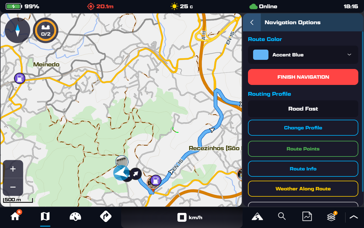
Navigation Options, opened from the instruction card.
Route Color
Pick the colour of the route line on the map — it persists across reroutes.
Routing Profile
Shows the current profile (e.g. Road Fast). Change Profile re-routes with a different style — see Routing Profiles.
Route Points & Info
Route Points lists your via-points; Route Info shows the route summary (distance, ascent, surface breakdown).
Set Active Group GPX
Under Save as GPX File, and only when you are in a riding group you can set the active GPX for. See Sharing Your Navigation With a Group.
Weather / Warnings On Route
Check the forecast — and weather / wildfire warnings — at points along your route before you set off. In mainland Portugal it also lists the official IPMA weather warnings and fire-danger levels for the districts you cross. See also the Warnings guide.
You don’t need a route to open it. With nothing navigating, the panel shows Warnings Where You Are instead — whatever applies at your own position right now. When you do have a route, that block sits at the top, above the along-the-route sections.
This panel opens with or without a license: the country modules are free, and this is the only screen that names the zones a warning covers. A license adds the per-stop forecast and the worldwide fire list — see Free vs. Licensed.
Measure Distances
Every distance is measured along the route, never as the crow flies: total length, start → you and you → end while you’re riding it, plus two tap modes — Two Point (tap two points on the line for the distance between them, highlighted on the map) and Single Point (tap one point for its distance to the start, the end and to you).
Save as GPX File
Save the active route to a GPX file you can reopen, share or ride again later — it’s added to your GPX list. A navigation you started from a map point is saved as Converted Route; one you started from a GPX keeps that route’s own name.
DMD2 then asks two short questions: Sync to HUB? (if you’re signed in) and Load Saved GPX to Map? Answer Not Now and the file simply waits in GPX Manager. Answer Load and it is drawn straight away — and because it now follows the same line as the navigation you are still running, DMD2 offers to finish that navigation so you are not left with two identical routes on the map.
Sharing Your Navigation With a Group
If you are leading a ride, the route in your head is the route the group needs. When you start navigating, DMD2 can hand that navigation straight to your riding group as its active GPX — everyone sees the line you are riding, without you planning and uploading anything.
You are asked at the moment the route finishes calculating, and only when all of this is true:
- a group is your active group;
- you are sharing your location with it;
- you are allowed to set its active GPX — owner, admin or moderator.
If something is already set as the group's active GPX, the question names it, so you know what the group loses before you replace it.
What it does — and doesn’t — touch
- The route goes straight to the group. It is not saved to your Loaded GPX Files and it does not appear in your HUB GPX Manager.
- The group’s copy is not drawn on your map while you are navigating it — you are already looking at the route, and two copies is just a thicker line. Every other member sees it as normal.
- Said Not Now? Set Active Group GPX waits in Navigation Options, under Save as GPX File, for the whole ride.
When your navigation ends
Whether you arrive or tap Finish Navigation, the group is still following your route — so DMD2 asks what to do with it:
- Keep Until Everyone Arrives — the group keeps the route. Your navigation is over, so it now appears on your map too, like it does for everyone else. It stays until you clear it from the group.
- Remove From Group — the group’s active GPX is cleared there and then.
This survives the app closing. If DMD2 is killed or restarted mid-ride, the link between your navigation and the group is picked up again on the next start — and if the navigation is gone but the group still has the route, you are asked the same question then, so the group is never left following a ride nobody is on.
Routing Profiles
The routing profile decides what kind of route DMD Router builds. Open it from Navigation Options → Change Profile:

The routing profiles and Recalculate — road options such as No Tolls sit just below the list.
Road Fast
Fastest route on paved roads.
Road Fun
Scenic, curvy roads — favours the enjoyable line over the quick one.
Match Any Road
Shortest way on any road or trail, paved or not — no preference between them. The same profile the Planner uses when converting a track to a route, so those routes reroute in the app exactly as planned. In the app it routes fully legal by default; its Legality Overrides can additionally allow private roads, special-permission roads and foot/bike paths, and turn off Avoid Barriers & Gates — the same soft avoid as in the Offroad profiles. The Planner defaults to all of them allowed and barriers not avoided.
Offroad Easy / Medium / Hard
Three grades of unpaved routing — from easy trails to challenging offroad terrain. Easy additionally steers clear of very rough surfaces on its own.
Advanced Adventure
Fully customizable adventure routing — fine-tune exactly what the route prefers and avoids.
Road Options
Under the profiles, toggle options such as No Tolls and No Motorways, or avoid certain road classes. Advanced Adventure adds scenic preferences — Prefer Forests / Rivers / Unpaved and Avoid Cities / Ferries / Private Roads. Tap Recalculate to rebuild the route with your choices.
Terrain & Legality (Offroad & Advanced Adventure)
The Offroad profiles and Advanced Adventure share a set of rider options. Avoid Barriers & Gates and Avoid Fords / Water Crossings are on by default and are soft avoids — the route steers around them as much as possible, but a destination or via point beyond one still routes through it. A gate on a private road counts as three ordinary gates, since those are the ones most likely to be locked. 4WD Tracks Priority prefers tracks tagged for four-wheel-drive when choosing between trails. The legality overrides — Route on Private Roads, Route on Special Permission Roads and Route on Foot & Bike Paths — open road classes that are otherwise only used as a last resort. The same options exist in the HUB Planner, and routes carry them inside their profile, so a route plans, previews and reroutes identically everywhere.
Community Routes
Community routes (online, with a licence): routes prefer the roads and tracks riders ride, the Community Ways. Auto prefers them on Road Fun, Offroad and Adventure and leaves Road Fast as it is; Prefer and Strongly prefer pull every profile, and Off leaves routes as they are. Match Any Road is never pulled. Road routes are pulled only onto paved community ways, off-road routes only onto unpaved ones unless you strongly prefer. Before you start, Suggest routes shows your route next to the community route, with distance, time, share on community ways and share unpaved.
Along the Route
Off-Route & Reroute
Wander off the line and DMD2 recalculates a fresh route from where you are — keeping your chosen profile and route colour. Rerouting always looks forward: it rejoins your planned route at the next point ahead of you, never back at the spot you left. A navigation you started always reroutes — riding along a loaded GPX track or route doesn’t pause it, and it keeps working no matter how far from the planned line you’ve wandered.
Arrival
On reaching your destination an arrival notice appears and guidance ends cleanly.
Speed & Camera Warnings
Speed-limit signs and speed-camera alerts show while navigating — detailed in the Warnings guide.
Weather & Fire Alerts
DMD2 can flag weather and wildfire hazards along your route — also covered in the Warnings guide.
Next Waypoint
When the GPX you’re riding carries waypoints, a line shows the next one ahead — its name, distance and arrival time (or remaining travel time — tap any time on the card to flip) — alongside its proximity alert. A track that passes the same waypoint more than once counts it at each pass, so the distance is always to the next time you actually reach it, never to a pass you already left behind.
Next Priority Waypoint
Star a waypoint as an objective — a checkpoint, a fuel stop, tonight’s hotel — and a second, amber line keeps its distance on screen while the line above carries on counting down the ordinary waypoints. See Priority Waypoints.
Off-Route Choices
Following a GPX route — or a navigation with stops along the way — brings up You are off route with three options:
- ReRoute To Line — rejoin your planned route further along and carry on following it. The original route stays exactly as you planned it.
- ReRoute To Next Point — skip the point you missed and navigate on to the next one. Keep riding your own way after that and each further prompt looks further along the route, so a point you are deliberately riding around gets skipped too instead of being offered again and again.
- Do Not Reroute — leave you to it. You won’t be asked again until you’re back on the route.
A countdown bar confirms the highlighted option, so you never have to take a hand off the bars. Out of the box it runs 10 seconds and highlights your last answer — ReRoute To Line, the choice that leaves your planned route untouched, on a fresh install. If the map isn’t on screen when you go off route, DMD Next applies the highlighted option for you rather than waiting. Rejoin the route under your own steam and the reroute clears itself.
All of this is yours to tune in GPX & Navigation → Off-Route & Re-Routing (the panel reminds you that a single-destination navigation always re-routes on its own; the options govern GPX routes and multi-stop navigations): set the countdown length (5–30 s), pin the pre-selected option or keep it on Last Used, decide whether these dialogs capture the remote controller (Always, Never, or Once per navigation — captured until you confirm the pre-selected choice or flip the dialog’s own switch), or turn the dialog off entirely and pick the one method applied silently every time you go off route.
That remote setting is also surfaced on the dialogs themselves as a Remote focus switch. Leave it on and a remote controller drives the dialog — up / down or the joystick moves the highlight, the confirm button answers. Switch it off on the dialog and, for the rest of this navigation, the dialogs stay touch-and-countdown only while the remote keeps working the map. It also switches itself off the moment you confirm the option that was already highlighted: you have shown you are happy with the default, so the remote goes back to the map. A new navigation starts with it on again. The same switch appears on the wrong-direction warning, on the Route Calculation Failed notice below, and on Rider Reports on Your Route.
If Route Calculation Fails
A navigation you started is never silently dropped. When a route calculation or recalculation can’t complete — no road near your position, no coverage, no connection — a Route Calculation Failed notice appears on the progress card with three choices:
- Change Profile — open the routing profile picker and try the calculation with a different profile.
- OK — dismiss the notice. Your navigation stays active, and DMD Next keeps retrying automatically as you move — get closer to a road and the route simply appears.
- End Navigation — stop the navigation.
If a recalculation fails mid-ride, you keep being guided on the previous route until a new one succeeds. Left untouched, the notice dismisses itself after 60 seconds — nothing is ended for you. And whenever a navigation is active but you’re away from its line, the card shows an Off Route line with your distance back to it, so the navigation is never invisible.
Continue Reading
Next up — GPX Tracks, Routes & Waypoints: import, manage and record GPX, and navigate a track.
GPX Tracks, Routes & Waypoints Map Overview